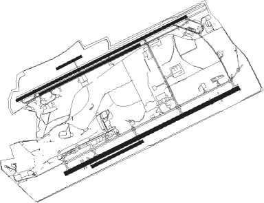
Manching - Ingolstadt-manching
Airport details
| Country | Germany |
| State | Bavaria |
| Region | ED |
| Airspace | Munich Ctr |
| Municipality | Landkreis Pfaffenhofen an der Ilm |
| Elevation | 1203ft (367m) |
| Timezone | GMT +1 |
| Coordinates | 48.71563, 11.53370 |
| Magnetic var | |
| Type | land |
| Available since | X-Plane v10.40 |
| ICAO code | ETSI |
| IATA code | IGS |
| FAA code | n/a |
Communication
| Ingolstadt-Manching IMA Dispatch | 131.700 |
| Ingolstadt-Manching Ingo Tower | 125.250 |
| Ingolstadt-Manching Ingo Radar | 120.600 |
| Ingolstadt-Manching Ingo Radar | 125.575 |
Approach frequencies
| ILS-cat-I | RW25L | 108.1 | 18.00mi |
| 3° GS | RW25L | 108.1 | 18.00mi |
Runway info
Nearby beacons
| code | identifier | dist | bearing | frequency |
|---|---|---|---|---|
| IGL | INGOLSTADT TACAN | 1.4 | 86° | 111.40 |
| IGL | INGOLSTADT NDB | 4.5 | 79° | 345 |
| MIQ | MIKE NDB | 9 | 156° | 426 |
| NEU | NEUBURG TACAN | 12.7 | 269° | 108.90 |
| WLD | WALDA VOR/DME | 18 | 251° | 112.80 |
| MNE | MUNICH NDB | 22.3 | 158° | 369 |
| DMN | DME | 23.3 | 143° | 116 |
| MSE | MUNICH NDB | 23.4 | 163° | 358 |
| DMS | DME | 24.5 | 147° | 115 |
| MNW | MUNICH NDB | 25.4 | 132° | 338 |
| MSW | MUNICH NDB | 26.3 | 134° | 400 |
| MAH | MAISACH VOR/DME | 28.5 | 206° | 115.20 |
| AUG | DME | 29.4 | 244° | 115.90 |
| AGB | AUGSBURG NDB | 29.5 | 244° | 318 |
| HFX | HOHENFELS NDB | 32.8 | 33° | 286 |
| OTT | OTTERSBERG VOR/DME | 34 | 152° | 112.30 |
| OBI | OBERPFAFFENHOFEN NDB | 39.3 | 201° | 429 |
| LCH | LECHFELD TACAN | 41.4 | 232° | 108.80 |
| RDG | RODING VOR/DME | 43.7 | 72° | 114.70 |
| RTB | ROETHENBACH NDB | 47.3 | 340° | 415 |
| ANS | ANSBACH NDB | 50.3 | 303° | 452 |
| NGD | DME | 50.4 | 330° | 113.10 |
| NUB | NUERNBERG VOR/DME | 51.1 | 328° | 115.75 |
| ERL | ERLANGEN VOR/DME | 58.4 | 338° | 114.90 |
| GRF | GRAFENWOHR TACAN | 60.7 | 23° | 111.80 |
| GRW | GRAFENWOHR NDB | 60.9 | 23° | 405 |
Instrument approach procedures
| runway | airway (heading) | route (dist, bearing) |
|---|---|---|
| RW07L | INGAP (174°) | INGAP 5000ft ERNAS (12mi, 266°) 5000ft SI441 (8mi, 183°) 5000ft SI442 (5mi, 124°) 3800ft ESEMI (4mi, 75°) 3000ft |
| RNAV | ESEMI 3000ft ETSI (6mi, 77°) 1245ft ETSI (turn) 2500ft INGAP (9mi, 354°) 5000ft INGAP (turn) 5000ft | |
| RW07R | INGAP (174°) | INGAP 5000ft ERNAS (12mi, 266°) 5000ft SI441 (8mi, 183°) 5000ft SI442 (5mi, 124°) 3800ft NOSDO (4mi, 82°) 3000ft |
| RNAV | NOSDO 3000ft ETSI (6mi, 72°) 1251ft ETSI (turn) 2500ft INGAP (9mi, 354°) 5000ft INGAP (turn) 5000ft | |
| RW25L | INGAP (174°) | INGAP 5000ft SI451 (12mi, 86°) 4000ft SI452 (6mi, 158°) 3600ft VADAN (7mi, 255°) 2900ft |
| RNAV | VADAN 2900ft ETSI (6mi, 258°) 1243ft ETSI (turn) 2500ft INGAP (9mi, 354°) 5000ft INGAP (turn) 5000ft | |
| RW25R | INGAP (174°) | INGAP 5000ft SI451 (12mi, 86°) 4000ft SI452 (6mi, 158°) 3600ft BILMU (8mi, 259°) 2900ft |
| RNAV | BILMU 2900ft ETSI (6mi, 253°) 1240ft ETSI (turn) 2500ft INGAP (9mi, 354°) 5000ft INGAP (turn) 5000ft |
Disclaimer
The information on this website is not for real aviation. Use this data with the X-Plane flight simulator only! Data taken with kind consent from X-Plane 12 source code and data files. Content is subject to change without notice.

