Hoogeveen
Airport details
| Country | Netherlands |
| State | Drenthe |
| Region | EH |
| Airspace | Amsterdam Ctr |
| Municipality | Hoogeveen |
| Elevation | 41ft (12m) |
| Timezone | GMT +1 |
| Coordinates | 52.73083, 6.51611 |
| Magnetic var | |
| Type | land |
| Available since | X-Plane v10.40 |
| ICAO code | EHHO |
| IATA code | n/a |
| FAA code | n/a |
Communication
| Hoogeveen Hoogeveen Information | 127.355 |
Nearby Points of Interest:
Gereformeerde kerk
-Karmelietenklooster
-Synagoge (Hoogeveen)
-Nederlands Hervormde Kerk
-Mariakerk, Ruinen
-Dwingeloo Radio Observatory
-watertoren Lutten
-Daglonershuisje met houten staldeel onder pannengedekt schilddak
-Mien Ruys Gardens
-Batinge
-Church of Zweeloo
-Hervormde Kerk
-Synagoge, Coevorden
-Bentheimerstraat 43
-Huize Voorwijk
-Dokter Larijweg 21, Ruinerwold
-Clemenskerk
-Huis Dennerode
-Huis Steinborg
-De Haarmolen
-Hervormde Kerk, Sleen
-Hervormde kerk
-Gemeentehuis van Sleen
-Molen van Schoonoord
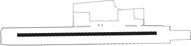
Runway info
| Runway 09 / 27 | ||
| length | 1081m (3547ft) | |
| bearing | 92° / 272° | |
| width | 24m (79ft) | |
| surface | grass | |
Nearby beacons
| code | identifier | dist | bearing | frequency |
|---|---|---|---|---|
| EEL | EELDE (GRONINGEN) VOR/DME | 26.5 | 19° | 112.40 |
| RKN | DME | 37 | 157° | 116.80 |
| LWD | LEEUWARDEN TACAN | 40.4 | 303° | 114.70 |
| DLN | DEELEN TACAN | 46.8 | 224° | 112.20 |
Disclaimer
The information on this website is not for real aviation. Use this data with the X-Plane flight simulator only! Data taken with kind consent from X-Plane 12 source code and data files. Content is subject to change without notice.