Ilminster - Rnas Merryfield
Airport details
| Country | United Kingdom |
| State | England |
| Region | |
| Airspace | London Ctr |
| Municipality | South Somerset |
| Elevation | 145ft (44m) |
| Timezone | GMT +0 |
| Coordinates | 50.96240, -2.95209 |
| Magnetic var | |
| Type | land |
| Available since | X-Plane v10.40 |
| ICAO code | EGDW |
| IATA code | n/a |
| FAA code | n/a |
Communication
Nearby Points of Interest:
Hatch Court
-Earnshill House
-Swell Court Farmhouse, Fivehead
-Thurlbear Wood and Quarrylands
-West Sedgemoor
-Freshmoor
-Ruttersleigh
-Curry and Hay Moors
-Midelney Manor
-West Moor SSSI
-Whitestaunton Manor
-East Lambrook Manor
-The Guildhall
-Hinton House
-Balt Moor Wall
-Prior's Park & Adcombe Wood
-Poundisford Park
-St Margaret's Almshouses
-Parrett Iron Works
-Former Stuckey and Bagehot Warehouse
-Gray's Almshouses, Taunton
-Maunsel House
-North Moor
-Southlake Moor
-Tudor House
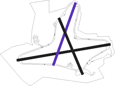
Runway info
Runway 09 / 27  | ||
| length | 1826m (5991ft) | |
| bearing | 87° / 267° | |
| width | 46m (151ft) | |
| surface | asphalt | |
| displ threshold | 53m (174ft) / 0m (0ft) | |
| Runway 03 / 21 | ||
| length | 1274m (4180ft) | |
| bearing | 35° / 215° | |
| width | 46m (151ft) | |
| surface | asphalt | |
| Runway 16 / 34 | ||
| length | 1169m (3835ft) | |
| bearing | 152° / 332° | |
| width | 46m (151ft) | |
| surface | asphalt | |
| displ threshold | 0m (0ft) / 110m (361ft) | |
Nearby beacons
| code | identifier | dist | bearing | frequency |
|---|---|---|---|---|
| YVL | YEOVIL NDB | 10.9 | 94° | 343 |
| YVL | DME | 11.3 | 94° | 109.05 |
| VLN | YEOVILTON TACAN | 12.1 | 82° | 111 |
| EX | EXETER NDB | 18.1 | 238° | 337 |
| BRI | BRISTOL NDB | 26.6 | 29° | 414 |
| CDF | CARDIFF NDB | 29.6 | 318° | 388 |
| OF | FILTON NDB | 36.1 | 33° | 325 |
| BHD | BERRY HEAD VOR/DME | 39.6 | 224° | 112.05 |
| BCN | BRECON VOR/DME | 47.2 | 338° | 117.45 |
| GST | GLOUCESTERSHIRE NDB | 63 | 40° | 331 |
Disclaimer
The information on this website is not for real aviation. Use this data with the X-Plane flight simulator only! Data taken with kind consent from X-Plane 12 source code and data files. Content is subject to change without notice.