Kamen - Kamen-heeren
Airport details
| Country | Germany |
| State | North Rhine-Westphalia |
| Region | ED |
| Airspace | Langen Ctr |
| Municipality | Kamen |
| Elevation | 206ft (63m) |
| Timezone | GMT +1 |
| Coordinates | 51.59033, 7.71000 |
| Magnetic var | |
| Type | land |
| Available since | X-Plane v10.45 |
| ICAO code | EDKE |
| IATA code | n/a |
| FAA code | n/a |
Communication
| Kamen-Heeren Kamen Info | 124.485 |
Nearby Points of Interest:
Herz-Jesu-Kirche (Heeren-Werve)
-Amtsgericht Unna
-Bahnhof Lenningsen
-Gutshof Schulze Heil
-Kantine Westfalia
-Ziegelei Siegeroth
-Amtsgericht Hamm
-Rathaus Hamm
-Haus Altendorf
-Jüdischer Friedhof
-Stuniken-Haus
-Bergbaubeamtensiedlung Neu-Asseln
-Amtsgericht Lünen
-Schloss Dahlhausen
-Burg Mark
-Werl Prison
-Amtsgericht Werl
-Johanneskirche
-Alfred-Fischer-Halle
-Haus Kotten
-Historische Kornbrennerei Bimberg
-Lippeschleuse Heessen
-Amtshaus Aplerbeck
-St. Joseph
-Betriebswerk Dortmund Betriebsbahnhof
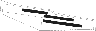
Runway info
Runway 11C / 29C  | ||
| length | 298m (978ft) | |
| bearing | 98° / 278° | |
| width | 28m (92ft) | |
| surface | grass | |
| Runway 11R / 29L | ||
| length | 393m (1289ft) | |
| bearing | 98° / 278° | |
| width | 29m (95ft) | |
| surface | grass | |
| Runway 11L / 29R | ||
| length | 244m (801ft) | |
| bearing | 98° / 278° | |
| width | 30m (98ft) | |
| surface | grass | |
Nearby beacons
| code | identifier | dist | bearing | frequency |
|---|---|---|---|---|
| DWI | DORTMUND-WICKEDE NDB | 4.7 | 230° | 357 |
| DOR | WICKEDE (DORTMUND) VOR/DME | 4.8 | 231° | 108.65 |
| HMM | HAMM VOR/DME | 16 | 360° | 115.65 |
| BAM | BARMEN VOR/DME | 25.4 | 244° | 114 |
| BOT | BOTTROP NDB | 25.6 | 270° | 406 |
| GMH | GERMINGHAUSEN VOR/DME | 26.1 | 157° | 115.40 |
| MOD | DME | 32.9 | 358° | 114.05 |
| LI | DUESSELDORF NDB | 33.9 | 253° | 417 |
| PAD | DME-ILS | 33.9 | 89° | 108.50 |
| MYN | MUENSTER/OSNABRUECK NDB | 34.3 | 9° | 371 |
| PAD | PADERBORN-LIPPSTADT NDB | 34.7 | 88° | 354 |
| WYP | WIPPER VOR | 36.3 | 218° | 109.60 |
| DUS | DUESSELDORF VOR/DME | 40.2 | 252° | 115.15 |
| OSB | OSNABRUCK TACAN | 42.3 | 43° | 108.35 |
| OSN | OSNABRUECK VOR | 42.3 | 43° | 114.30 |
| LW | COLOGNE-BONN NDB | 44.9 | 213° | 300 |
| LJ | COLOGNE-BONN NDB | 46.6 | 224° | 365 |
| RKN | DME | 47.8 | 300° | 116.80 |
| COL | COLA VOR/DME | 48.6 | 188° | 108.80 |
| KBO | COLOGNE-BONN VOR/DME | 48.6 | 218° | 112.15 |
| LV | COLOGNE-BONN NDB | 50.4 | 211° | 327 |
| SLD | DME | 54.8 | 157° | 108.05 |
| SIL | SIEGERLAND NDB | 57 | 155° | 489 |
Disclaimer
The information on this website is not for real aviation. Use this data with the X-Plane flight simulator only! Data taken with kind consent from X-Plane 12 source code and data files. Content is subject to change without notice.