Béchar - Bechar
Airport details
| Country | Algeria |
| State | Bashar |
| Region | DA |
| Airspace | Algiers Ctr |
| Elevation | 2661ft (811m) |
| Timezone | GMT +1 |
| Coordinates | 31.65057, -2.25315 |
| Magnetic var | |
| Type | land |
| Available since | X-Plane v10.40 |
| ICAO code | DAOR |
| IATA code | CBH |
| FAA code | n/a |
Communication
Approach frequencies
| ILS-cat-I | RW18 | 108.1 | 18.00mi |
| 3° GS | RW18 | 108.1 | 18.00mi |
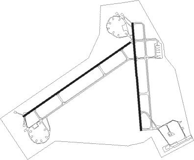
Runway info
Runway 06 / 24  | ||
| length | 3610m (11844ft) | |
| bearing | 64° / 244° | |
| width | 45m (148ft) | |
| surface | asphalt | |
| displ threshold | 0m (0ft) / 300m (984ft) | |
| blast zone | 12m (39ft) / 0m (0ft) | |
| Runway 18 / 36 | ||
| length | 2978m (9770ft) | |
| bearing | 180° / 360° | |
| width | 45m (148ft) | |
| surface | asphalt | |
| blast zone | 25m (82ft) / 25m (82ft) | |
Nearby beacons
| code | identifier | dist | bearing | frequency |
|---|---|---|---|---|
| BCR | BECHAR NDB | 1.1 | 36° | 407 |
| BCR | BECHAR VOR/DME | 2 | 347° | 113.90 |
| BRF | BOUARFA VOR/DME | 53 | 14° | 117 |
Disclaimer
The information on this website is not for real aviation. Use this data with the X-Plane flight simulator only! Data taken with kind consent from X-Plane 12 source code and data files. Content is subject to change without notice.