Chamberlain - Chamberlain Muni
Airport details
| Country | United States of America |
| State | South Dakota |
| Region | K3 |
| Airspace | Minneapolis Ctr |
| Municipality | Chamberlain |
| Elevation | 1692ft (516m) |
| Timezone | GMT -6 |
| Coordinates | 43.76614, -99.32123 |
| Magnetic var | |
| Type | land |
| Available since | X-Plane v10.40 |
| ICAO code | 9V9 |
| IATA code | n/a |
| FAA code | n/a |
Communication
| Chamberlain Muni CTAF/UNICOM | 122.800 |
Nearby Points of Interest:
Chamberlain Bridge
-Holy Trinity Church
-Church of Christ in LaRoche Township
-Hilton House (White Lake, South Dakota)
-Underwood United Methodist Church
-Hofmeister House
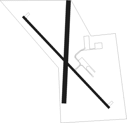
Runway info
Runway 13 / 31  | ||
| length | 1308m (4291ft) | |
| bearing | 132° / 312° | |
| width | 23m (75ft) | |
| surface | asphalt | |
| blast zone | 183m (600ft) / 0m (0ft) | |
| Runway 18 / 36 | ||
| length | 1040m (3412ft) | |
| bearing | 190° / 10° | |
| width | 46m (150ft) | |
| surface | grass | |
Nearby beacons
| code | identifier | dist | bearing | frequency |
|---|---|---|---|---|
| PIR | PIERRE VORTAC | 52.3 | 307° | 112.50 |
| HO | BEADY (HURON) NDB | 58.8 | 55° | 302 |
Instrument approach procedures
| runway | airway (heading) | route (dist, bearing) |
|---|---|---|
| RW13 | DAWSN (132°) | DAWSN 4400ft |
| RNAV | DAWSN 4400ft FIDVI (7mi, 132°) 3400ft JURSU (3mi, 132°) 2600ft 9V9 (3mi, 131°) 1736ft (5809mi, 114°) 2080ft COCOA (5802mi, 294°) 3600ft COCOA (turn) | |
| RW31 | COCOA (312°) | COCOA 3600ft |
| RNAV | COCOA 3600ft FAINS (6mi, 312°) 3400ft 9V9 (6mi, 312°) 1718ft (5809mi, 114°) 2040ft DAWSN (5815mi, 294°) 4400ft DAWSN (turn) |
Disclaimer
The information on this website is not for real aviation. Use this data with the X-Plane flight simulator only! Data taken with kind consent from X-Plane 12 source code and data files. Content is subject to change without notice.