Fort Benton
Airport details
| Country | United States of America |
| State | Montana |
| Region | K1 |
| Airspace | Salt Lake City Ctr |
| Municipality | Fort Benton |
| Elevation | 2869ft (874m) |
| Timezone | GMT -7 |
| Coordinates | 47.84511, -110.63648 |
| Magnetic var | |
| Type | land |
| Available since | X-Plane v10.40 |
| ICAO code | 79S |
| IATA code | n/a |
| FAA code | n/a |
Communication
| FORT BENTON CTAF/UNICOM | 122.800 |
Nearby Points of Interest:
Masonic Building
-Fort Benton Engine House
-Chouteau County Courthouse
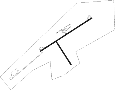
Runway info
Runway 5 / 23  | ||
| length | 1307m (4288ft) | |
| bearing | 70° / 250° | |
| width | 23m (75ft) | |
| surface | asphalt | |
| Runway 14 / 32 | ||
| length | 585m (1919ft) | |
| bearing | 141° / 321° | |
| width | 23m (75ft) | |
| surface | dirt | |
Nearby beacons
| code | identifier | dist | bearing | frequency |
|---|---|---|---|---|
| GTF | GREAT FALLS VORTAC | 39.3 | 243° | 115.10 |
| HVR | HAVRE VOR/DME | 54.2 | 51° | 114.65 |
Instrument approach procedures
| runway | airway (heading) | route (dist, bearing) |
|---|---|---|
| RW23 | ANALE (294°) | ANALE JOTUN (12mi, 16°) 6000ft JOTUN (turn) 5000ft |
| RW23 | BELCA (215°) | BELCA JOTUN (10mi, 141°) 5000ft |
| RNAV | JOTUN 5000ft KEVKE (7mi, 250°) 4800ft 79S (6mi, 250°) 2900ft (6227mi, 113°) 3270ft JOTUN (6214mi, 293°) 5000ft JOTUN (turn) |
Disclaimer
The information on this website is not for real aviation. Use this data with the X-Plane flight simulator only! Data taken with kind consent from X-Plane 12 source code and data files. Content is subject to change without notice.