Edgemont - Edgemont Muni
Airport details
| Country | United States of America |
| State | South Dakota |
| Region | K3 |
| Airspace | Denver Ctr |
| Municipality | Fall River County |
| Elevation | 3604ft (1098m) |
| Timezone | GMT -7 |
| Coordinates | 43.29525, -103.84354 |
| Magnetic var | |
| Type | land |
| Available since | X-Plane v10.40 |
| ICAO code | 6V0 |
| IATA code | n/a |
| FAA code | n/a |
Communication
| Edgemont Muni CTAF | 122.900 |
Nearby Points of Interest:
Chilson Bridge
-Mammoth Site, Hot Springs
-Phillip Wesch House
-Hot Springs High School
-Governor Leslie Jensen House
-Wind Cave National Park Administrative and Utility Area Historic District
-Beaver Creek Bridge
-Beaver Creek Rockshelter
-Pig Tail Bridge
-Buffalo Gap Historic Commercial District
-Historic Trail and Cave Entrance
-Jewel Cave Ranger Station
-Hudson-Meng Bison Kill
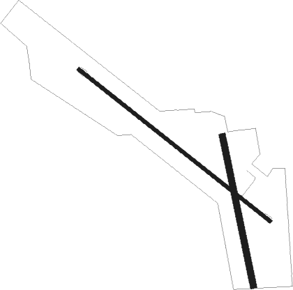
Runway info
Runway 12 / 30  | ||
| length | 1190m (3904ft) | |
| bearing | 124° / 304° | |
| width | 18m (60ft) | |
| surface | asphalt | |
| Runway 16 / 34 | ||
| length | 743m (2438ft) | |
| bearing | 170° / 350° | |
| width | 30m (100ft) | |
| surface | grass | |
Nearby beacons
| code | identifier | dist | bearing | frequency |
|---|---|---|---|---|
| ECS | NEWCASTLE VOR | 40.5 | 322° | 108.20 |
| HIN | WHITNEY (CHADRON) NDB | 43.2 | 122° | 275 |
| CD | DAWES (CHADRON) NDB | 43.7 | 129° | 362 |
| TST | TOADSTOOL VOR/DME | 50 | 144° | 113.40 |
| RAP | RAPID CITY VORTAC | 54.5 | 51° | 112.30 |
| RCA | ELLSWORTH (RAPID CITY) TACAN | 60 | 41° | 108.80 |
Disclaimer
The information on this website is not for real aviation. Use this data with the X-Plane flight simulator only! Data taken with kind consent from X-Plane 12 source code and data files. Content is subject to change without notice.