Sheridan
Airport details
| Country | United States of America |
| State | Indiana |
| Region | K5 |
| Airspace | Chicago Ctr |
| Municipality | Hamilton County |
| Elevation | 936ft (285m) |
| Timezone | GMT -5 |
| Coordinates | 40.17793, -86.21730 |
| Magnetic var | |
| Type | land |
| Available since | X-Plane v10.40 |
| ICAO code | 5I4 |
| IATA code | n/a |
| FAA code | 5I4 |
Communication
| Sheridan CTAF/UNICOM | 123.075 |
| Sheridan INDIANAPOLIS Approach/Departure | 124.650 |
Nearby Points of Interest:
Sheridan Downtown Commercial Historic District
-Davenport-Bradfield House
-Kirklin Public Library
-Union High Academy Historic District
-Tipton County Courthouse
-Tipton County Jail and Sheriff's Home
-Simpson-Breedlove House
-Nickel Plate Road 587
-Dr. Samuel Harrell House
-Catherine Street Historic District
-Robert L. Wilson House
-Hamilton County Courthouse
-Judge Earl S. Stone House
-Noblesville Commercial Historic District
-Noblesville Milling Company Mill
-South 9th Street Historic District
-Daniel Craycraft House
-William Houston Craig House
-Conner Street Historic District
-Holliday Hydroelectric Powerhouse and Dam
-Thornhurst Addition
-John Kinzer House
-Pryor Brock Farmstead
-Maplelawn Farmstead
-Micah Newby House
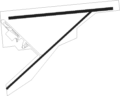
Runway info
Runway 5 / 23  | ||
| length | 1148m (3766ft) | |
| bearing | 59° / 239° | |
| width | 15m (50ft) | |
| surface | asphalt | |
| displ threshold | 191m (627ft) / 6m (20ft) | |
| Runway 09 / 27 | ||
| length | 1034m (3392ft) | |
| bearing | 89° / 269° | |
| width | 27m (88ft) | |
| surface | grass | |
| displ threshold | 0m (0ft) / 76m (249ft) | |
Nearby beacons
| code | identifier | dist | bearing | frequency |
|---|---|---|---|---|
| UMP | METROPOLITAN (INDIANAPOLIS) NDB | 16.3 | 145° | 338 |
| OKK | KOKOMO VORTAC | 22.2 | 24° | 113.50 |
| VHP | BRICKYARD VORTAC | 22.8 | 202° | 116.30 |
| FV | LAREZ (INDIANAPOLIS) NDB | 23.5 | 177° | 349 |
| GUS | GRISSOM (PERU) VORTAC | 28.2 | 8° | 108.45 |
| MZZ | MARION VOR/DME | 31 | 60° | 108.60 |
| CO | COLFA (INDIANAPOLIS) NDB | 31.3 | 177° | 232 |
| AI | VIDEO (ANDERSON) NDB | 33 | 99° | 394 |
| CFJ | CRAWFORDSVILLE NDB | 34.2 | 254° | 388 |
| SHB | SHELBYVILLE VOR/DME | 37.4 | 144° | 112 |
| MIE | MUNCIE VOR/DME | 37.9 | 86° | 114.40 |
| LA | EARLE (LAFAYETTE) NDB | 41 | 287° | 401 |
| JN | BALLL (MUNCIE) NDB | 41.1 | 90° | 365 |
| MI | BALLL (MUNCIE) NDB | 41.1 | 90° | 365 |
| UWL | NEW CASTLE NDB | 45 | 108° | 385 |
| BVT | BOILER (LAFAYETTE) VORTAC | 45.1 | 294° | 115.10 |
| BA | CLIFS (COLUMBUS) NDB | 54.6 | 155° | 410 |
| HLB | BATESVILLE NDB | 66.7 | 131° | 254 |
Instrument approach procedures
| runway | airway (heading) | route (dist, bearing) |
|---|---|---|
| RW05 | JAKKS (89°) | JAKKS ZACMU (19mi, 94°) 2600ft DELLS (5mi, 134°) 2600ft |
| RW05 | WELDO (297°) | WELDO RAZEE (13mi, 248°) 2600ft DELLS (5mi, 315°) 2600ft |
| RNAV | DELLS 2600ft ATLEE (5mi, 59°) 2600ft ZILIT (3mi, 59°) 1560ft 5I4 (2mi, 58°) 980ft (5232mi, 115°) 1336ft BROOG (5224mi, 295°) 2700ft BROOG (turn) | |
| RW23 | BROOG (239°) | BROOG 2700ft |
| RW23 | CLANG (297°) | CLANG DEEKS (12mi, 342°) 2900ft BROOG (5mi, 315°) 2700ft |
| RW23 | OKK (204°) | OKK SOUKS (11mi, 195°) 2700ft BROOG (5mi, 135°) 2700ft |
| RNAV | BROOG 2700ft GOEAR (5mi, 239°) 2700ft 5I4 (5mi, 240°) 982ft (5232mi, 115°) 1800ft BROOG (5224mi, 295°) 2700ft BROOG (turn) |
Disclaimer
The information on this website is not for real aviation. Use this data with the X-Plane flight simulator only! Data taken with kind consent from X-Plane 12 source code and data files. Content is subject to change without notice.