Mott - Mott Muni
Airport details
| Country | United States of America |
| State | North Dakota |
| Region | K3 |
| Airspace | Minneapolis Ctr |
| Municipality | Hettinger County |
| Elevation | 2411ft (735m) |
| Timezone | GMT -7 |
| Coordinates | 46.35917, -102.32825 |
| Magnetic var | |
| Type | land |
| Available since | X-Plane v10.40 |
| ICAO code | 3P3 |
| IATA code | n/a |
| FAA code | n/a |
Communication
| Mott Muni CTAF | 122.900 |
Nearby Points of Interest:
Hettinger County Courthouse
-Dr. S.W. Hill Drug Store
-Neuburg Congregational Church
-Adams County Courthouse
-Lemmon Petrified Park
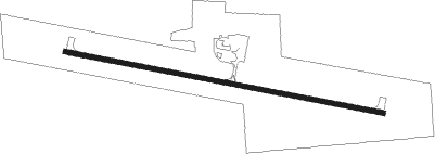
Runway info
| Runway 10 / 28 | ||
| length | 1218m (3996ft) | |
| bearing | 101° / 281° | |
| width | 18m (60ft) | |
| surface | asphalt | |
Nearby beacons
| code | identifier | dist | bearing | frequency |
|---|---|---|---|---|
| LEM | LEMMON VOR | 27.9 | 153° | 111.40 |
| DIK | DICKINSON VORTAC | 35.2 | 318° | 112.90 |
| HZE | HAZEN NDB | 64.2 | 38° | 414 |
Disclaimer
The information on this website is not for real aviation. Use this data with the X-Plane flight simulator only! Data taken with kind consent from X-Plane 12 source code and data files. Content is subject to change without notice.