Elkhart - Mishawaka Pilots Club
Airport details
| Country | United States of America |
| State | Indiana |
| Region | |
| Airspace | Chicago Ctr |
| Municipality | Elkhart County |
| Elevation | 753ft (230m) |
| Timezone | GMT -5 |
| Coordinates | 41.65601, -86.03337 |
| Magnetic var | |
| Type | land |
| Available since | X-Plane v10.40 |
| ICAO code | 3C1 |
| IATA code | n/a |
| FAA code | 3C1 |
Communication
| Mishawaka Pilots Club CTAF | 122.900 |
Nearby Points of Interest:
Charles Gerard Conn Mansion
-Emmanuel C. Bickel House
-Elkhart Downtown Commercial Historic District
-Joseph and Sarah Puterbaugh Farm
-Green Block
-Morehous Residential Historic District
-Dr. Havilah Beardsley House
-Beardsley Avenue Historic District
-State Street-Division Street Historic District
-Ruthmere Mansion
-Mark L. and Harriet E. Monteith House
-William and Helen Koerting House
-Eller-Hosford House
-Garth Stroup Home
-Dodge House
-Beiger Mansion
-Normain Heights Historic District
-Old Mishawaka Carnegie Library
-Mishawaka Reservoir Caretaker's Residence
-Battell Park Historic District
-Kamm and Schellinger Brewery
-Ellis-Schindler House
-St. John's Lutheran Church
-Colonial Gardens Commercial Historic District
-James A. Judie House
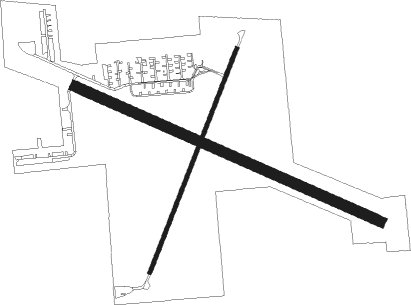
Runway info
Runway 3 / 21  | ||
| length | 688m (2257ft) | |
| bearing | 33° / 213° | |
| width | 12m (40ft) | |
| surface | asphalt | |
| displ threshold | 57m (187ft) / 61m (200ft) | |
| Runway 12 / 30 | ||
| length | 958m (3143ft) | |
| bearing | 112° / 292° | |
| width | 30m (100ft) | |
| surface | grass | |
| displ threshold | 0m (0ft) / 210m (689ft) | |
Nearby beacons
| code | identifier | dist | bearing | frequency |
|---|---|---|---|---|
| GSH | GOSHEN VORTAC | 7.8 | 178° | 113.70 |
| SB | MISHA (SOUTH BEND) NDB | 8.8 | 285° | 341 |
| GIJ | GIPPER (NILES) VORTAC | 14.4 | 292° | 115.40 |
| IRS | STURGIS NDB | 28.4 | 75° | 382 |
| ELX | KEELER VOR/DME | 29.6 | 350° | 116.60 |
| OXI | KNOX VOR/DME | 34.2 | 242° | 115.60 |
| OLK | WEBSTER LAKE VOR | 34.4 | 127° | 110.40 |
| AZ | AUSTN (KALAMAZOO) NDB | 36.3 | 47° | 371 |
| VP | SEDLY (VALPARAISO) NDB | 39.8 | 256° | 212 |
| AZO | KALAMAZOO VOR/DME | 40.9 | 40° | 109 |
| PMM | PULLMAN VOR/DME | 48.7 | 355° | 112.10 |
| FWA | FORT WAYNE VORTAC | 55.7 | 129° | 117.80 |
| BT | BATOL (BATTLE CREEK) NDB | 56.8 | 50° | 272 |
Disclaimer
The information on this website is not for real aviation. Use this data with the X-Plane flight simulator only! Data taken with kind consent from X-Plane 12 source code and data files. Content is subject to change without notice.