Waynesville - Caesar Creek
Airport details
| Country | United States of America |
| State | Ohio |
| Region | |
| Airspace | Indianapolis Ctr |
| Municipality | Warren County |
| Elevation | 937ft (286m) |
| Timezone | GMT -5 |
| Coordinates | 39.47694, -84.09918 |
| Magnetic var | |
| Type | land |
| Available since | X-Plane v10.40 |
| ICAO code | 2OH9 |
| IATA code | n/a |
| FAA code | 2OH9 |
Communication
Nearby Points of Interest:
Bone Stone Graves
-Bone Mound II
-Waynesville Main Street Historic District
-Crossed Keys Tavern
-Mohrman-Jack-Evans House
-Hillside Haven Mound
-Berryhill-Morris House
-Springboro Historic District
-Dr. Aaron Wright House
-Moar Mound and Village Site
-Cowan Creek Circular Enclosure
-Charles Butler House
-Franklin Post Office
-Keiter Mound
-Clinton County Courthouse
-Rombach Place
-Doan House
-Market Square (Miamisburg, Ohio)
-Charles F. Kettering House
-Voice of America Bethany Relay Station
-McDonald Farm
-John B. Tytus House
-South Main Street District
-Bank of Xenia
-Alexander Conner House
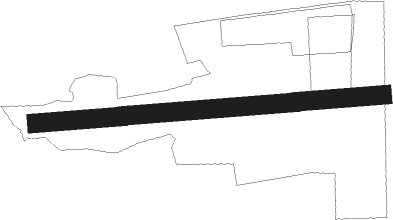
Runway info
| Runway 09 / 27 | ||
| length | 858m (2815ft) | |
| bearing | 90° / 270° | |
| width | 46m (150ft) | |
| surface | grass | |
Nearby beacons
| code | identifier | dist | bearing | frequency |
|---|---|---|---|---|
| MW | ONIDA (MIDDLETOWN) NDB | 12 | 294° | 223 |
| HW | CUBLA (WILMINGTON) NDB | 12.7 | 119° | 299 |
| MXQ | MIDWEST (WILMINGTON) VOR/DME | 14.1 | 99° | 112.90 |
| HKF | HOOK FIELD (MIDDLETOWN) NDB | 16.1 | 274° | 239 |
| IL | AIRBO (WILMINGTON) NDB | 16.7 | 87° | 407 |
| FFO | PATTERSON (DAYTON) TACAN | 20.6 | 7° | 115.20 |
| SGH | DME | 24.5 | 35° | 113.20 |
| PWF | SPORTYS (BATAVIA) NDB | 24.6 | 196° | 245 |
| AT | BRUNY (DAYTON) NDB | 24.7 | 327° | 315 |
| XSF | SPRINGFIELD TACAN | 24.7 | 36° | 133.80 |
| CSS | COURT HOUSE (WASHINGTON) NDB | 33.6 | 80° | 414 |
| DQN | DAYTON VOR/DME | 35.1 | 331° | 114.50 |
| RID | RICHMOND VOR/DME | 38 | 291° | 110.60 |
| CVG | CINCINNATI VORTAC | 39.4 | 233° | 117.30 |
| BU | BOUTN (COLUMBUS) NDB | 46.1 | 69° | 230 |
| ROD | ROSEWOOD VORTAC | 48.7 | 4° | 117.50 |
| FLM | FALMOUTH VOR/DME | 50.6 | 194° | 117 |
| OS | FULER (COLUMBUS) NDB | 54.9 | 56° | 515 |
| AWW | WINCHESTER NDB | 56.2 | 310° | 212 |
Disclaimer
The information on this website is not for real aviation. Use this data with the X-Plane flight simulator only! Data taken with kind consent from X-Plane 12 source code and data files. Content is subject to change without notice.