Bowling Green - Wood Co
Airport details
| Country | United States of America |
| State | Ohio |
| Region | K5 |
| Airspace | Cleveland Ctr |
| Municipality | Bowling Green |
| Elevation | 668ft (204m) |
| Timezone | GMT -5 |
| Coordinates | 41.39100, -83.63014 |
| Magnetic var | |
| Type | land |
| Available since | X-Plane v10.40 |
| ICAO code | 1G0 |
| IATA code | n/a |
| FAA code | n/a |
Communication
| Wood Co AWOS 3 | 120.725 |
| Wood Co CTAF/UNICOM | 122.800 |
| Wood Co TOLEDO Approach/Departure | 126.100 |
Nearby Points of Interest:
Wood County Courthouse and Jail
-Floral Hall
-Dodge Site
-Fallen Timbers Battlefield
-Hull-Wolcott House
-Georg Cronenwett House
-Christopher C. Layman Law Office
-Old School Privy
-Libbey High School
-Inverness Club
-Edward D. Libbey House
-Tower on the Maumee
-Lucas County Courthouse and Jail
-James M. Ashley and Thomas W.L. Ashley United States Courthouse
-Michaels Farm
-Toledo Yacht Club
-Adams School
-First Hancock County Courthouse
-Henry County Sheriff's Residence and Jail
-Henry County Courthouse
-Soldiers and McKinley Memorial Parkways
-Spiegel Grove
-North Maumee Bay Archeological District
-Sandusky County Jail and Sheriff's House
-Joseph and Rachel Bartlett House
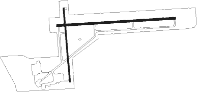
Runway info
Runway 10 / 28  | ||
| length | 1278m (4193ft) | |
| bearing | 91° / 271° | |
| width | 23m (75ft) | |
| surface | asphalt | |
| Runway 18 / 36 | ||
| length | 804m (2638ft) | |
| bearing | 179° / 359° | |
| width | 15m (50ft) | |
| surface | asphalt | |
| displ threshold | 0m (0ft) / 17m (56ft) | |
Nearby beacons
| code | identifier | dist | bearing | frequency |
|---|---|---|---|---|
| TOL | TOLEDO TACAN | 14.3 | 320° | 112.50 |
| TO | TOPHR (TOLEDO) NDB | 16.3 | 299° | 219 |
| TII | TIFFIN NDB | 25.8 | 126° | 269 |
| FBC | FLAG CITY VORTAC | 26.7 | 196° | 108.20 |
| ADG | ADRIAN NDB | 35 | 317° | 278 |
| PCW | PORT CLINTON NDB | 35.1 | 80° | 423 |
| CRL | CARLETON VOR/DME | 40.2 | 15° | 115.70 |
| TCU | TECUMSEH NDB | 40.2 | 338° | 239 |
| DT | REVUP (DETROIT) NDB | 44.6 | 15° | 388 |
| RYS | GROSSE ILE (DETROIT) NDB | 47.7 | 34° | 419 |
| DXO | DETROIT VOR/DME | 50.7 | 18° | 113.40 |
| BUD | BUCKEYE (MARION) VOR | 53.1 | 144° | 109.80 |
| DM | SPENC (DETROIT) NDB | 53.3 | 27° | 223 |
| JXN | DME | 63.9 | 316° | 115.45 |
| QG | WINDSOR NDB | 64.9 | 40° | 353 |
Instrument approach procedures
| runway | airway (heading) | route (dist, bearing) |
|---|---|---|
| RW10 | LEYIR (115°) | LEYIR UBAYA (7mi, 181°) 2300ft |
| RW10 | UBAYA (91°) | UBAYA 6000ft UBAYA (turn) 2300ft |
| RW10 | WUDAT (72°) | WUDAT UBAYA (5mi, 1°) 2300ft |
| RNAV | UBAYA 2300ft ZIMBO (6mi, 91°) 2300ft 1G0 (5mi, 91°) 712ft (5118mi, 116°) 939ft MELIS (5107mi, 296°) 2300ft MELIS (turn) | |
| RW18 | JUMAK (178°) | JUMAK 2300ft |
| RNAV | JUMAK 2300ft IYOBI (6mi, 179°) 2300ft 1G0 (5mi, 176°) 711ft (5118mi, 116°) 922ft ZABDU (5118mi, 296°) 2400ft ZABDU (turn) | |
| RW28 | KOREW (288°) | KOREW MELIS (5mi, 360°) 2300ft |
| RW28 | MELIS (271°) | MELIS 6000ft MELIS (turn) 2300ft |
| RW28 | SEHSI (252°) | SEHSI MELIS (5mi, 176°) 2300ft |
| RNAV | MELIS 2300ft YOHKO (6mi, 271°) 2300ft 1G0 (5mi, 270°) 712ft (5118mi, 116°) 923ft UBAYA (5130mi, 296°) 2300ft UBAYA (turn) | |
| RW36 | ZABDU (0°) | ZABDU 2400ft |
| RNAV | ZABDU 2400ft OLOCI (6mi, 359°) 2300ft 1G0 (5mi, 2°) 712ft (5118mi, 116°) 1073ft JUMAK (5120mi, 296°) 2300ft JUMAK (turn) |
Disclaimer
The information on this website is not for real aviation. Use this data with the X-Plane flight simulator only! Data taken with kind consent from X-Plane 12 source code and data files. Content is subject to change without notice.