Fowler
Airport details
| Country | United States of America |
| State | Kansas |
| Region | |
| Airspace | Kansas City Ctr |
| Municipality | Meade County |
| Elevation | 2481ft (756m) |
| Timezone | GMT -6 |
| Coordinates | 37.38142, -100.18808 |
| Magnetic var | |
| Type | land |
| Available since | X-Plane v10.40 |
| ICAO code | 18K |
| IATA code | n/a |
| FAA code | 18K |
Communication
| Fowler CTAF | 122.900 |
Nearby Points of Interest:
Fowler Swimming Pool and Bathhouse
-Dalton Gang Hideout and Museum
-Big Basin Prairie Preserve
-Girl Scout Little House
-Stockgrowers State Bank
-Stein House
-Dodge City Public Library
-Old Gray County Courthouse
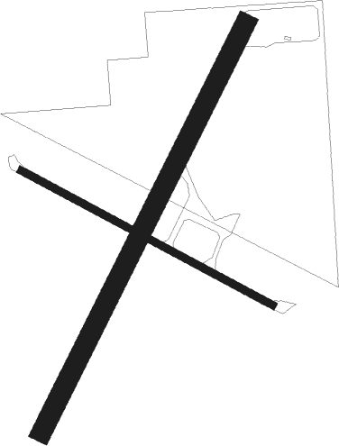
Runway info
Runway 03 / 21  | ||
| length | 705m (2313ft) | |
| bearing | 37° / 217° | |
| width | 30m (100ft) | |
| surface | grass | |
| Runway 12 / 30 | ||
| length | 441m (1447ft) | |
| bearing | 117° / 297° | |
| width | 12m (40ft) | |
| surface | grass | |
Nearby beacons
| code | identifier | dist | bearing | frequency |
|---|---|---|---|---|
| DDC | DODGE CITY VORTAC | 29.4 | 21° | 108.20 |
| GC | PIEVE (GARDEN CITY) NDB | 37 | 310° | 347 |
| GCK | GARDEN CITY VORTAC | 41.1 | 315° | 113.30 |
| LBL | LIBERAL VORTAC | 42.5 | 247° | 112.30 |
| LB | PANCK (LIBERAL) NDB | 44.4 | 242° | 383 |
| PYX | PERRYTON NDB | 64.1 | 210° | 266 |
Disclaimer
The information on this website is not for real aviation. Use this data with the X-Plane flight simulator only! Data taken with kind consent from X-Plane 12 source code and data files. Content is subject to change without notice.