Holly Ridge - Camp Davis Mcolf
Airport details
| Country | United States of America |
| State | North Carolina |
| Region | |
| Airspace | Washington Ctr |
| Municipality | Marine Corps Base Camp Lejeune |
| Elevation | 60ft (18m) |
| Timezone | GMT -5 |
| Coordinates | 34.53436, -77.54241 |
| Magnetic var | |
| Type | land |
| Available since | X-Plane v10.40 |
| ICAO code | 14NC |
| IATA code | n/a |
| FAA code | 14NC |
Communication
| Camp Davis MCOLF CHERRY POINT Approach | 119.350 |
Nearby Points of Interest:
Yopps Meeting House
-Sloop Point
-Bank of Onslow and Jacksonville Masonic Temple
-Burgaw Depot
-Venters Farm Historic District
-Palo Alto Plantation
-Gabriel's Landing
-Mount Lebanon Chapel and Cemetery
-Bradley-Latimer Summer House
-Brookwood Historic District
-Wilmington National Cemetery
-Carolina Place Historic District
-Market Street Mansion District
-Carolina Heights Historic District
-Delgrado School
-James Walker Nursing School Quarters
-Westbrook–Ardmore Historic District
-Thalian Hall
-Alton Lennon Federal Building and Courthouse
-Wilmington Historic District
-Eagle Nest
-Sanderson House
-Bryan-Bell Farm
-Bryan Lavender House
-Foscue Plantation House
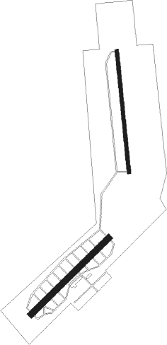
Runway info
Runway 18 / 36  | ||
| length | 1527m (5010ft) | |
| bearing | 179° / 359° | |
| width | 46m (150ft) | |
| surface | concrete | |
| Runway 5 / 23 | ||
| length | 1364m (4475ft) | |
| bearing | 55° / 235° | |
| width | 80m (262ft) | |
| surface | asphalt | |
Nearby beacons
| code | identifier | dist | bearing | frequency |
|---|---|---|---|---|
| DIW | DIXON NDB | 4.8 | 69° | 198 |
| NCA | NEW RIVER TACAN | 11.5 | 31° | 115.40 |
| OA | ELLAS (JACKSONVILLE) NDB | 15.2 | 323° | 261 |
| GM | WILZE NDB | 17.8 | 234° | 205 |
| ILM | WILMINGTON VORTAC | 19.7 | 241° | 117 |
| IL | AIRLI (WILMINGTON) NDB | 26.1 | 223° | 281 |
| EW | KAFTI (NEW BERN) NDB | 37.1 | 44° | 362 |
| NKT | CHERRY POINT TACAN | 39.6 | 61° | 112.80 |
| EWN | NEW BERN VOR/DME | 40.6 | 43° | 113.60 |
| IS | STALS (KINSTON) NDB | 43.2 | 348° | 276 |
| CTZ | CLINTON NDB | 48.3 | 298° | 412 |
| ISO | KINSTON VORTAC | 50.2 | 359° | 109.60 |
| GSB | SEYMOUR JOHNSON TACAN | 52.5 | 332° | 116.50 |
| RNW | CHOCOWINITY NDB | 62.3 | 24° | 388 |
| JN | JURLY (SMITHFIELD) NDB | 71.2 | 317° | 263 |
Disclaimer
The information on this website is not for real aviation. Use this data with the X-Plane flight simulator only! Data taken with kind consent from X-Plane 12 source code and data files. Content is subject to change without notice.