Rolla - Rolla Muni
Airport details
| Country | United States of America |
| State | North Dakota |
| Region | K3 |
| Airspace | Minneapolis Ctr |
| Municipality | Rolette County |
| Elevation | 1819ft (554m) |
| Timezone | GMT -6 |
| Coordinates | 48.88442, -99.62075 |
| Magnetic var | |
| Type | land |
| Available since | X-Plane v10.40 |
| ICAO code | 06D |
| IATA code | n/a |
| FAA code | n/a |
Communication
| Rolla Muni CTAF/UNICOM | 122.800 |
Nearby Points of Interest:
Coghlan Castle
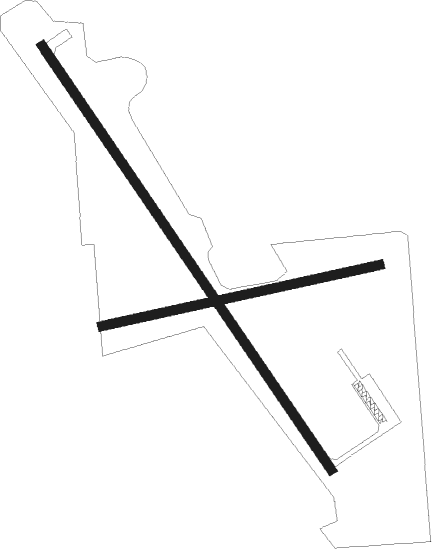
Runway info
Runway 14 / 32  | ||
| length | 1311m (4301ft) | |
| bearing | 139° / 319° | |
| width | 23m (75ft) | |
| surface | asphalt | |
| Runway 07 / 25 | ||
| length | 726m (2382ft) | |
| bearing | 85° / 265° | |
| width | 23m (75ft) | |
| surface | grass | |
Nearby beacons
| code | identifier | dist | bearing | frequency |
|---|---|---|---|---|
| DVL | DEVILS LAKE VOR/DME | 54.1 | 137° | 114.75 |
Instrument approach procedures
| runway | airway (heading) | route (dist, bearing) |
|---|---|---|
| RW32 | BALTA (32°) | BALTA UTACI (39mi, 47°) 3400ft |
| RW32 | DVL (317°) | DVL UTACI (43mi, 317°) 3400ft |
| RW32 | UTACI (319°) | UTACI 3400ft |
| RNAV | UTACI 3400ft SEMGE (6mi, 319°) 3400ft 06D (5mi, 319°) 1862ft (5784mi, 116°) 2067ft BALTA (5806mi, 296°) 3800ft BALTA (turn) |
Disclaimer
The information on this website is not for real aviation. Use this data with the X-Plane flight simulator only! Data taken with kind consent from X-Plane 12 source code and data files. Content is subject to change without notice.